Cancer rates and geography
14 August 2026
Cancer is a non-communicable disease, which together with cardiovascular disease, are responsible for about 60% of deaths in New Zealand. It is important to understand potential links between cancer and geography.
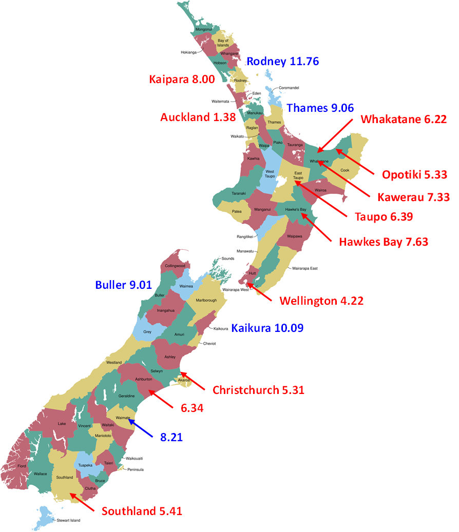
Cancer rates (cancers/1,000/year) in selected districts around New Zealand.
Geographic Information Systems (GIS) are hardware, software, technologies, and tools that enable the storage, retrieval, visualization, and analysis of geographic features and associated data.
These tools are becoming increasingly important in cancer surveillance and the determination of how cancer starts, spreads, and is controlled in groups of people (epidemiology).
Modern GIS can be used to map cancer prevalence in order to look for potential associations between high cancer rates and environmental and industrial emissions. Uncovering potential associations is not as simple as it sounds since cancer incidence can be associated with a mixture of genetic, life-style and environmental factors. In other words cancer is a disease that is subject to many confounding effects.
Another important consideration with cancer is that there can be long delays between exposure to cancer-causing agents and the development of symptoms. Since people move around they could be exposed to cancer-causing agents in one place and not develop the disease until later in life after having moved place of residence, possibly many times.
However, if there were a particular industry that contributed in a significant way to environmental effects, such as through pollution of the atmosphere or water, then that might show up on a GIS map.
In 2024 I had suggested councils of the Eastern Bay of Plenty include a health dimension in the spatial plan that had been under development for the better part of a decade. When I couldn’t get traction for the idea I decided to take action myself. In early 2025 I submitted an Official Information Act request to Health NZ (HNZ) for cancer data from the national cancer database. I was after cancer rates by either letter box or post code. New Zealand has 67 districts and about 1,800 post codes.
HNZ denied my request for cancer incidence by letter box and post code citing privacy concerns. I protested but to no effect. I suggested that if they wouldn’t provide the numbers then they should do the research themselves. HNZ did provide cancer incidence at the district level. HNZ cautioned that the numbers were provisional and had not been through quality assurance. That the numbers have not had quality assurance tells me that as recently as 2025 HNZ and the Ministry of Health are not actually using the cancer data.
I have recently converted the raw numbers into cancer incidence rates per 1,000 of population for each district and put the data on the New Zealand district map.
It can be seen that the cancer rates for the Eastern Bay of Plenty are 5.33, 6.22 and 7.33 for Ōpotiki, Whakatāne and Kawerau districts in that order. The EBOP rates are not far from the NZ average of 6.24 cancers per 1,000 per year. The cancer rates in Auckland are curiously low and need to be validated.
The rate for Kawerau is particularly interesting since the district covers an area of only 24 km2 and has a high density of timber and Pulp and Paper (P&P) industry. Also, much of the resident population works in the mills.
There are few industries that do not generate some kind of pollution. Since we live in a region of NZ with a considerable concentration of P&P industries, and since there has been some concern regarding the contribution that these industries can make to disease in our area, it is worth considering this industry in more detail. The production of pulp and paper can give rise to the pollution of land, water and air. Land and water pollution represent a risk to ecosystems and people. Air pollution in particular can present an inhalation risk.
Pulp, and to a lesser extent paper mills, emit a range of gases and particulate matter to the atmosphere. Gases like carbon monoxide (CO), nitrogen oxides (NOx), hydrogen sulphide (H2S), sulphur dioxide (SO2) and other malodourous sulphur compounds as well as other organic compounds. Also produced are quantities of particulate matter in different size ranges. Normally there are environmental limits that an industry must comply with and I trust that our local mills are compliant.
If Kawerau were a cancer hot-spot due atmospheric emissions from local industries, then I would have expected to see significantly elevated cancer rates in the district. Whilst it is reassuring that this was not the case, much more work would be required to be more conclusive about any findings. It should also be noted that P&P mills are not the only industry around the EBOP.
It is interesting that Kaikura, Rodney and Buller have cancer rates that are significantly above the national average. Rodney is in fact almost twice the national average. I wonder what is special about these three districts?
Although the approach taken here has many limitations, and a lot of additional work would be required to make firm conclusions, we can take some heart from these provisional data. Additional work would be required to firm-up the data, reduce the spatial granularity (at least to post code level) and break cancer types down by type (lung, breast, prostate etc) in addition to better defining the history of point sources of pollution and so on. My interaction with HNZ suggests that they collect the data. There is no use collecting data if nothing is done with it.
My intent in writing this article is to promote the idea that the research be done. If you think so too, then by all means write to relevant authorities.
References
Dionne, J., Walker, T.R. Air pollution impacts from a pulp and paper mill facility located in adjacent communities, Edmundston, New Brunswick, Canada and Madawaska, Maine, United States. Environmental Challenges 2021, 5, 100245. https://doi.org/10.1016/j.envc.2021.100245
Dixit, M., Gupta, G.K., Liu, H., Shukla, P. Pulp and paper industry based pollutants, their health hazards and environmental risks. Current Opinion in Environmental Science & Health, PII: S2468-5844(19)30047-9. DOI: https://doi.org/10.1016/j.coesh.2019.09.010
Giacosa, G., Barnett, C., Rainham, D.G., Walker, T.R. Characterization of Annual Air Emissions Reported by Pulp and Paper Mills in Atlantic Canada. Pollutants 2022, 2(2), 135-155. https://doi.org/10.3390/pollutants2020011
Giacosa, G., Rainham, D.G., Walker, T.R. A baseline characterization of fine particulate matter (PM2.5) concentration and releases in Nova Scotia, Canada. Atmos. Pollution Res. 2023, 14(5), 101757. https://doi.org/10.1016/j.apr.2023.101757
Monge-Corella, S., Garcia-Perez, J., Aragones, N., Pollan, M., Perez-Gomez, B. Lopez-Abente, G. Lung cancer mortality in towns near paper, pulp and board industries in Spain: a point source pollution study. BMC Public Health, 2008, 14(8), 288. https://doi:10.1186/1471-2458-8-288
Newland, A., Halamek, J. Ramkumar, S. Remediation of Per- and Polyfluoroalkyl Substances in Nonwoven Production and Paper Sectors: A Brief Review. AATCC Journal of Research, 2024, 11(3), 229-238. https://doi.org/10.1177/24723444241237301
Sahar, L., Foster, S.L., Sherman, R.L., Henry, K.A., Goldberg, D.W., Stinchcomb, D.G. and Bauer, J.E. (2019), GIScience and cancer: State of the art and trends for cancer surveillance and epidemiology. Cancer, 2019, 125, 2544-2560. https://doi.org/10.1002/cncr.32052
Singh, A.K., Chandra, R. Environmental pollutants of paper industry wastewater and their toxic effects on human health and ecosystem. Bioresource Technology Reports 2022, 20, 101250. https://doi.org/10.1016/j.biteb.2022.101250


Comments