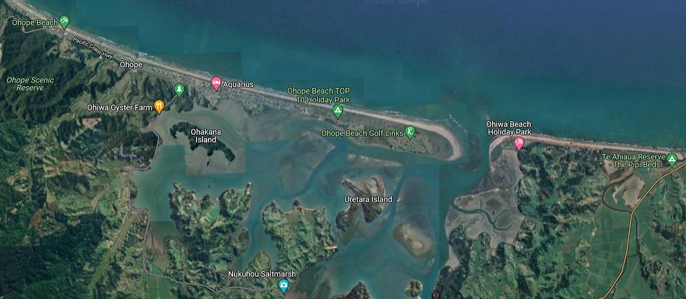
Ohiwa Harbor - A Bit of Background
- vicluca
- Aug 25, 2022
- 4 min read
Updated: Aug 26, 2022
Dr Victor Luca
25-Aug-22
There are two places in which to moor boats in the Whakatāne area. One of those places is the Whakatāne river and the other is the Ohiwa Harbor estuary to the east.
The Whakatāne River starts its life in the heavily forested Urewera Country some 5.6 km west-north-west from Lake Waikaremoana. Adjacent watersheds are Rangitaiki to the west, the Mohaka to the south, and the Wairoa to the south-east.

Source: Reference [1].
The Rangitaiki river starts its journey from the Ahimanawa Ranges before traveling through broad flat pumice dominated geology used for pastoral agriculture and pine plantations. As the river travels north-east through the Kaingaroa Forest it is dominated to the east by the Ikuwhenua Ranges in Te Urewera National Park before emerging on the Galatea flood plain, which is covered by dairy farms.
But it was the Whakatane river that the Matatua Canoe, one of the main canoes comprising the Great Fleet, where first landfall was made c.a. AD 1350. The rocky entrance to the river mouth is relatively shallow and it always has been.

The Ohiwa estuary is located a few kilometers to the east of the Whakatāne township along Ohope beach and it is a natural harbor affording shelter and moorings for relatively large vessels. At least five iwi and hapu lay claim to the area surrounding the estuary.
Johnston in his report to the Waitangi tribunal [1] writes the following about Ohiwa harbor.
According to Van der Wouden, regular steamship services began in 1867 to Whakatāne and Opotiki, but due to the difficulties regularly encountered in entering both these harbors, the steamer was often diverted to Ohiwa where there was deeper water and a better entrance channel.
Goods were unloaded on the Ohiwa Spit and transported to Opotiki by horse and cart and to Whakatāne by whaleboat, while passengers were forced to make their own way. In D.G.’s account of one such unscheduled visit to Ohiwa in January 1873, mentioned above, he wrote that the steamer Southern Cross:
Landed passengers and goods during a mizzling rain upon what might well be termed a most inhospitable looking sand beach, having only one or two raupo whares for the accommodation of the Maori ferryman, this being the highway for travellers from Opotiki northwards towards Tauranga, the crossing here by water being about 800 yards wide.
Ducker described the shipping to Ohiwa as ‘very regular as the bar could always be worked on the high tide’. He recalled regular weekly visits of the Ngati Awa, under Captain Keatley, bringing cargo and passengers to the eastern Bay of Plenty.He recalled regular weekly visits of the Ngatiawa, under Captain Keatley, bringing cargo and passengers to the eastern Bay of Plenty.
According to Ducker:
Opotiki bar was rarely workable so most cargo was shipped through Ohiwa. The butter from the Opotiki Dairy Co. was shipped along with the cheese from Waiotahi Cheese Factory, and the Waimana Cheese Factory. Also Cheddar Valley butter, but that was much later. It was established in 1916.
Ducker recalled that, having an all-weather bar, the port of Ohiwa ‘was never without coastal ships or scows coming or going. There was much produce to be shipped out from the Eastern Bay of Plenty, mostly through Ohiwa’.
During severe northerly storms as many as fifteen vessels would take shelter in the harbour, ‘the shallower draft scows anchored up harbour as far as Ducker’s Island’.
Du Pontet likewise stresses the importance of Ohiwa as a port; from as early as the 1880s and 1890s and into the early years of the twentieth century, she writes, ‘Ohiwa Harbour was the most used harbor in the Eastern Bay of Plenty’.
According to Du Pontet:
Lying between the river ports of Opotiki and Whakatane, which had bar depths of only six to eight feet at high tide involving constant difficulties for vessels trying to enter in stormy weather or in draught, Ohiwa was well open, having a constantly open bar channel with at least twelve feet of water. It was then no uncommon thing to see two or three coastal steamers lying in deep water or at the wharf, waiting until the other two ports should be workable.
The harbour, according to Du Pontet, was often busy.

The Whakatāne river and bar (background) showing the types of vessels that entered.
So it would seem that the use of the Ohiwa as a relatively accessible and sheltered harbor goes back a long way. The entrance was quite navigable more than 100 years ago and remains so today. The water depth is greater than that of the Whakatāne river bar.
With all of that history Whakatāne District Council has chosen to develop a Commercial Boat Harbor 4 kilometers up river from the Whakatāne bar. That will require pushing water for 4 km at a maximum speed of 9 km/h (5 knots) making for a 30 minute trip just to get to the river mouth. In that time the average trailer boat could easily be at Whale Island. Think of the wasted fuel.
Whakatāne is a trailer boat town. We should have kept it that way.
References
[1] Johnston, E. Ohiwa Harbour - A Report Commissioned by the Waitangi Tribunal. March 2003.
[2] Leonard, G., Begg, J. & Wilson, C. Geology of the Rotorua area. January 2010. GNS Science, Jane Forsyth (Ed.), ISBN: 978-0-478-19778-5.


Comments